


Services we offer
At True North Aerial, we deliver professional drone solutions that combine precision, efficiency, and cutting-edge technology.
Our services range from agricultural spraying that targets only what needs treatment, to thermal imaging for inspections, search and rescue, and public safety support. We provide real estate aerial marketing, construction progress tracking, mapping and surveying, and environmental monitoring—all with high-resolution visuals and real-time data.
With advanced drones like the DJI Matrice 4T, we capture the big picture and the smallest details—whether that’s tracking a suspect from the sky, scanning a field for crop stress, mapping a large property, or showcasing a home from a breathtaking aerial perspective.
When every angle matters, we’re there to deliver accurate results, safer operations, and stunning imagery.

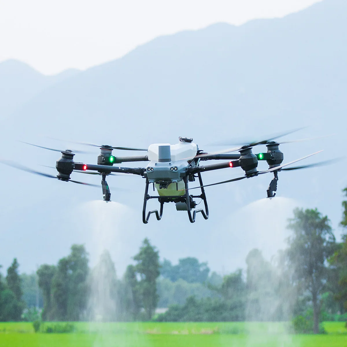
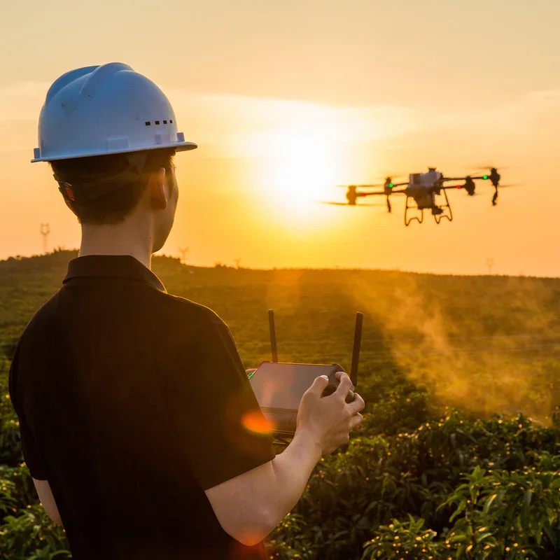
Agricultural Drone Spraying
Our agricultural spraying drones deliver precision-targeted applications that reduce overspray, minimize waste, and protect your crops. Using GPS-guided flight paths and advanced variable-rate spraying technology, we can apply herbicides, pesticides, fungicides, and nutrients only where needed—ensuring an even, thorough, and cost-effective treatment.
Benefits: Saves up to 30% in chemical usage, prevents chemical drift into non-target areas, reduces soil compaction by eliminating heavy ground equipment, and allows treatment in wet or inaccessible terrain.
Applications: Row crops, orchards, vineyards, pastures, and spot-treatment for invasive weeds.
Pricing:
Spot Spraying: $8–$12/acre
Full Coverage: $10–$15/acre
Minimum Job: $200
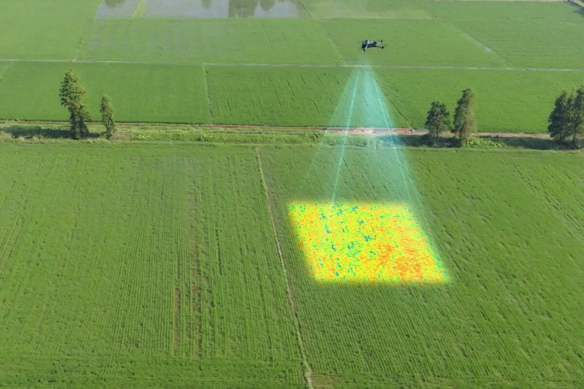
Multispectral Crop Analysis
Our drones use multispectral and NDVI/NDRE imaging to detect plant stress before it’s visible to the human eye. This allows for early intervention, helping you address pests, disease, nutrient deficiencies, and irrigation issues before they impact yield.
Benefits: Maximizes yields by pinpointing problem areas, enables targeted treatment, and supports sustainable farming by reducing unnecessary inputs.
Applications: Crop health mapping, growth staging, yield prediction, and replanting decisions.
Pricing: $8–$12/acre (includes analysis report and georeferenced maps)

Thermal Imaging & Inspection
Equipped with high-resolution FLIR thermal sensors, our drones detect heat variations that can indicate electrical faults, insulation leaks, livestock locations, or hidden fire hotspots. Perfect for agriculture, emergency response, industrial inspections, and wildlife monitoring.
Benefits: Non-invasive, rapid, and able to operate in low-light or zero-visibility conditions.
Applications: Identifying equipment failures, monitoring irrigation systems, tracking wildlife movement, and detecting wildfire embers before they spread.
Pricing:
Residential/Structural: $200–$400/job
Wildland/Livestock Surveys: $250/hr
Emergency Response: Custom Quote

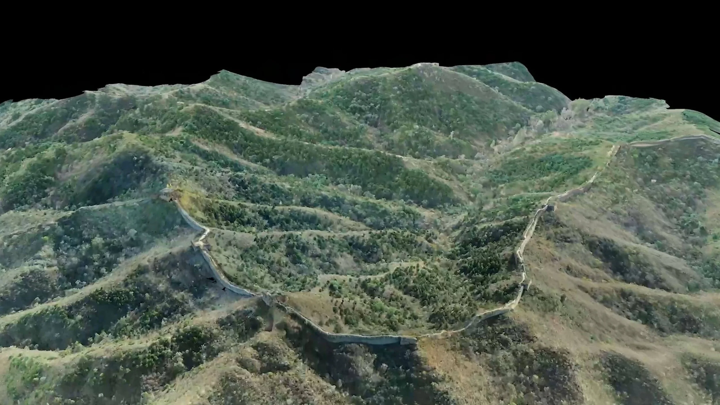
Drone Mapping & 3D Modeling
We create high-resolution aerial maps and 3D models using photogrammetry to capture every contour and detail of your land or project. Ideal for construction planning, agricultural field management, real estate marketing, and environmental studies.
Benefits: Accurate measurements without expensive ground surveying, faster project planning, and reduced labor costs.
Applications: Orthomosaic mapping, elevation models, volumetric stockpile measurements, and 3D terrain modeling.
Pricing:
Standard Mapping: $100–$300/flight
Detailed 3D Modeling: +$50/hr for processing
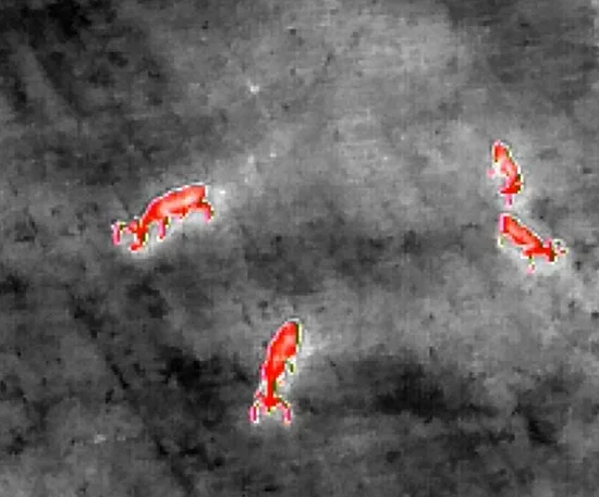
Lost Pet & Injured Wildlife Search
Using thermal imaging and zoom cameras, our drones can quickly cover large areas to locate missing pets, livestock, or injured wildlife—even in heavy brush, dense forests, or at night.
Benefits: Faster recovery, reduced search area, and lower risk to search teams.
Applications: Lost dogs/cats, escaped livestock, post-disaster animal rescue, and wildlife conservation efforts.
Pricing:
Standard Search: $150–$300/mission (1–2 hours)
Emergency Call-Out: +$50–$100 surcharge
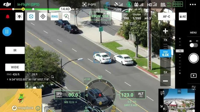
Public Safety Support
Our advanced drones provide critical aerial support for law enforcement, fire, and search-and-rescue operations. With thermal imaging, zoom lenses, and tracking technology, we can:
Locate suspects quickly while keeping officers out of harm’s way.
Track vehicles, boats, or individuals in real-time with continuous aerial surveillance.
Map crime and accident scenes for evidence documentation.
Provide overwatch during tactical operations or large public events.
Detect hidden fire hotspots for firefighter safety.
Benefits: Increases safety for responders, delivers instant situational awareness, and operates where manned aircraft are impractical.
Pricing:
Public Safety Missions: $250/hr (1 hr min)
Standby/Event Coverage: Custom Contract


Real Estate Imaging & Marketing
Showcase properties with breathtaking aerial perspectives that make listings stand out and sell faster. Using our DJI Matrice 4T’s 20MP visual camera, 200× hybrid zoom, and stabilized gimbal system, we capture crystal-clear imagery that highlights every angle, from sweeping neighborhood views to fine architectural details.
Dynamic Aerial Photography: High-resolution stills capture property scale, landscaping, and surrounding amenities in a way ground-level photos simply can’t.
4K Cinematic Video: Smooth, stabilized footage perfect for marketing reels, virtual tours, and promotional materials.
Detail-Oriented Close-Ups: Use the zoom lens to highlight roofing, siding, or unique features without ladders or scaffolding.
Twilight & Sunrise Shots: Our advanced low-light capabilities deliver stunning imagery during the golden hours that grab buyer attention.
Full Property Context: Showcase nearby lakes, parks, schools, and infrastructure to increase buyer interest.
Thermal Integration (Optional): Provide added value for buyers or inspectors with roof heat-loss checks, solar panel inspections, or hidden water damage detection.
Pricing:
Residential Package (photos + video): $250–$450
Commercial Package: $400–$800
Add Thermal Roof Scan: + $150
Drone Training & Certification Prep
Whether you’re a farmer, first responder, or hobbyist turning pro, we offer hands-on training to get you flying safely, legally, and effectively. Our courses include FAA Part 107 test prep, field practice, and operational best practices for agricultural, thermal, and mapping missions.
Benefits: Learn from certified pilots with real-world experience, get personalized instruction, and leave ready to operate commercially.
Pricing:
1-Day Course: $350–$600/person
Group/Agency Rates: Available

Consultation & Custom Drone Solutions
We work directly with you to develop a drone program tailored to your needs. Whether you need help choosing the right equipment, creating flight plans, or integrating drones into your workflow, we can deliver a clear, cost-effective strategy.
Benefits: Avoid costly trial-and-error, maximize ROI, and gain access to expert insight from experienced drone operators.
Pricing:
Initial Phone/Email Consult: Free or $50
On-Site Assessment: $150–$300
Contact us
Interested in working together? Fill out some info and we will be in touch shortly. We can’t wait to hear from you!